
Maps – How Most of our Adventures Start
I like maps. I’ll take a map over GPS any day. I like looking at and discovering spatial, geographical relationships. I like reminding myself that Los Angeles is still east of Lake Tahoe. Maps are marvelous. They show places and roads you didn’t even know existed.
On a recent trip to NorCal, I was perusing a map of Humboldt County and oooh, looky there! If you start in Redcrest on Avenue of the Giants (which is exactly where I was whilst perusing said map) and drive south to Dyerville, you can turn west onto Mattole Road, drive through Humboldt Redwoods State Park to Lighthouse Road, visit the Punta Gorda Lighthouse (abandoned) then go back to Mattole Road and head north along the Lost Coast, then northeast to Ferndale, back to the 101 and head south, pick up Avenue of the Giants again and you’re back where you started. It’s about 100 miles by my rough calculation, which should take about 2 hours to drive, but add an hour, maybe two, for stops and lunch and we’ll be back at camp for dinner.
Sounds like an incredible adventure! Let’s go!
Funny thing about maps, though. Not all are to scale. This one said it wasn’t. Not all streets are shown. This one didn’t, but in retrospect, it’s interesting which roads DID make the map (I’m looking at you, Wilder Ridge Road). And this particular map, which highlighted 101 Things to Do in Humboldt County, did NOT list Mattole Road and all the points of interest along the way. Curious. Clearly an oversight. Who wouldn’t want to drive through Humboldt Redwoods State Park? Or go to the Lost Coast? Who wouldn’t want to see Punta Gorda Lighthouse (abandoned)? Or drive through Cape Mendocino, a very important, geologically-speaking, spot on the map? Who wouldn’t want to visit Ferndale (again)? I had no answers to these questions, but adventure awaited, so off we went.
Mattole Road – Humboldt Redwoods State Park
I’m not sure what time we actually left, but our first stop, in Humboldt Redwoods State Park was after noon. The redwoods are spectacularly beautiful. Tall majestic trees surrounded by lush undergrowth, including but not limited to an abundance of poison oak. Yippee. My penchant for flip-flops was decidedly dangerous in these environs. Our first stop was shady, with a creek and lots of interesting plants.
Interesting little tidbit, Mattole Road started off as two lanes and less than 1/4 mile in, it became a one lane road. A road with no line down the middle. There was plenty of room for passing and there was a significant amount of traffic here as there are a lot of visitors to the park. I should also note that Mattole Road quickly became a rough road. Rough enough that we were driving around potholes and roots. Our ~10 mile excursion through the park took a little longer than anticipated.


Mattole Road – Over the River and Hills and Through the Woods to Honeydew We Go
As you leave Humboldt Redwoods State Park, you drive over a range of hills and down into a valley. And by over a range of hills, I mean you drive over Mount Everest. And by Mount Everest, I mean Grasshopper Peak. The road doesn’t go over the peak, it just feels like it does. And then you drive down Mount Everest. This road that is not a road is sometimes one lane, sometimes two, sometimes asphalt in various states of repair and disrepair and sometimes it’s dirt/gravel. It’s bumpy. Ridiculously bumpy and potholey. We were jostled every which way when each wheel hit a different hole or root or mangled asphalt. Did I mention it is steep? With hairpin turns in which you could see yourself coming and going? Yeah. It was exciting and quite the ab workout all at the same time.
My estimate for driving time was off since we couldn’t drive anywhere near 50 mph. It was more like 10 mph with sporadic bursts of 25 mph. Calling Mattole Road a road is generous. Why are there no photos of this Mount Everest drive? Because. It was all I could do to hang on and not bang my head into unconsciousness. Despite the harrowing drive, the area is sparsely populated and is beautifully pastoral. As you descend down into the valley, you pass cattle and sheep ranches and a quarry. At last you cross a steel covered bridge and arrive in Beautiful Downtown Honeydew. It is truly a blink-and-you’ll-miss-it town.


Honeydew is mostly a wide spot in the road with one big building that is the post office, the general store, a cafe and a gas station. Well, a gas pump anyway. There were a surprising number of people in Honeydew, and I suppose most of them were just like us; grateful to have made it there intact, in dire need of a bathroom and something stronger than water to drink. We had a lot more driving to do, so we settled for Diet Cokes and a stroll.
I noticed the sign coming into Honeydew from the east says you can turn left (south) and go to Ettersburg, or turn right (west) and go to Petrolia and Ferndale. But if you enter Honeydew from the west, a sign says you can head south and go to both Ettersburg and Briceland. Apparently, you can only go to Briceland if you’re coming from the west.


I chatted with the man behind the counter in the country store. He asked which way we were headed and when I told him the Lost Coast, he said, “Good. The road to Ettersburg is really bad.” Huh.
After a short rest, we forged on. The so-called road to Petrolia and Ferndale was in equally good shape. Our plan was to find Lighthouse Road and take a short detour to Point Gorda and visit the Lost Coast and Point Gorda Lighthouse (abandoned). My map showed that just before we crossed Mattole River, Lighthouse Road would be on our left. Yes, well. We crossed a lot of rivers between Honeydew and Petrolia.
Did I mention there is no cell service in this very rural part of the beautiful state of California? No? Well, there isn’t. I had the fabulous, but not to scale and does not show all streets map and no access to any other sources of directions or maps. We did have GPS in the car, but we didn’t have an address or Point of Interest to enter and the GPS map also did not show all roads, but it was to scale. So we drove. We dodged and skirted. Bouncing and jostling and bumping our way across lots of bridges over unnamed rivers. We passed ranches with happy California cows and wildflowers. We saw quite a few roads to our left. But we weren’t there yet.


The Lost Coast and Punta Gorda Lighthouse (abandoned)
It turns out Lighthouse Road had good signage and we hadn’t missed our turn even though we thought we had because there were so many bridges and we were looking for the one that had Lighthouse Road veering to our left before we crossed a bridge. Phew! So we turned left and headed down a road just like the one we had been on. Oh joy. No rest for the kidneys.
The road paralleled Mattole River and there was a significant change in the weather as we approached the Lost Coast. It was more humid and cooler and breezier and as we pulled into Mattole Beach Campground, it was sort of foggy and sort of not. There were bathrooms (yay!) and a big sign with lots of information about the beach and the trails and the lighthouse…wait…what? The lighthouse is a 5 mile hike from Mattole Beach? Erg. Nowhere on my map that isn’t to scale and doesn’t show all roads does it say that the Punta Gorda Lighthouse (abandoned – it does say that!) isn’t right there at the end of Lighthouse Road. We were definitely not prepared for a hike on a very windy, sandy beach. No Punta Gorda Lighthouse (abandoned) viewing on this trip. Oh well. We layered on sweatshirts and grabbed camera gear and headed to Mattole Beach.
Mattole Beach is wild and windy and raging. It is part of California’s Lost Coast, the longest undeveloped stretch of shoreline in the state.The Lost Coast and the King Range is an area in NorCal, in both Humboldt and Mendocino Counties. It apparently got its name when most of the population in the area left in the 1930s. Because of the steep coastal mountains, no major highways were built in the area. The small towns of Petrolia, Honeydew and Shelter Cove are isolated and can only be accessed by small, mountain roads.
Much of the land and the Lost Coast are part of the King Range National Conservation Area and the Sinkyone Wilderness State Park. Because it is so rural and difficult to get to, the area is a good place to visit if you’re looking for solitude. You can camp at Mattole Beach, and there are more campgrounds further south near Shelter Cove. Shelter Cove (a post for another day) is more developed with hotels, campgrounds and vacation rentals. The main attraction though, is the hike along the beach from Mattole Campground to the Black Sands Beach Trailhead in Shelter Cove (or vice versa). You can drive to Shelter Cove and Mattole Beach. If you want to see more of the Lost Coast, you have to hike it!


Mattole Road – Petrolia, Zebras and Rocking and Rolling
Back on Mattole Road, we headed northwest to Petrolia, 5 miles from the coast. Petrolia is not a quaint seaside town with gift shops, cafes and delightful little inns enticing travelers to come and stay awhile. Instead, you’ll find another blink-and-you’ll-miss-it town with a general store, 1 gas pump, a fire station, a church and a post office. I think I saw a B&B as we headed out of town, there is a cafe and rumor has it there is a local coffee roaster and a winery. There is no tourism here; it’s an isolated area with a population that prefers it stay that way.
Petrolia is also where the first oil well was drilled in California, hence, Petrolia. Fortunately for us, oil production wasn’t at all what was expected and transportation was a problem so the oil industry didn’t take hold here.
We stopped for a few photos and a handful of wild blackberries (these are everywhere! yum!).


About halfway between Petrolia and the coast, we spied zebras and horses. We saw two zebras in a field of golden grass, and about 200 yards from them was a group of horses hanging about in the shade. The zebras appeared to be watching the horses, and of course I imagined them taunting the horses, saying, “Ha! We’re fancy and you’re not.” I was just turning back to the car when a rock in the field started rolling around and then stood up. It was a zebra foal! Right about this time, a local drove past, stopped and told us about how the male zebra was recently shot and killed. As far as I know, there is still no known motive nor do they know who shot Randy, the male Zebra. The mother of the foal is Josephine, the other zebra is LC (for Lost Coast) and is the offspring of Randy and Josephine, as is the foal, whose name I don’t know. For the life of me, I cannot imagine why someone would shoot a zebra and leave it to die.


Mattole Road – Cape Mendocino to Ferndale
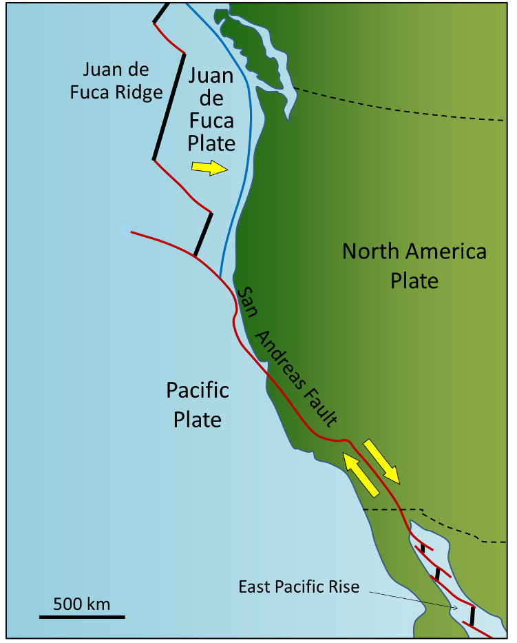
If you’ve made it this far, I’m sure you’re dying to know why Cape Mendocino is an important geological location. Well, I’ll tell you why. Two things: it is the westernmost point on the California coast and it is one of the most seismically active areas in the U.S. Just off shore is the Mendocino Triple Junction where the Pacific, North American and Gorda (a section of the Juan de Fuca plate) tectonic plates meet, forming the Mendocino Fracture Zone. In this area, the Pacific Plate is moving northwestward, the Gorda Plate is moving eastward and subducting under the southwest-moving North American Plate and the Gorda Plate meets the San Andreas Fault at the subduction zone. So if you stand there long enough, you will probably feel an earthquake. Hopefully, a small earthquake. Not the kind that sets off the Tsunami warning sirens.

Despite being an area of rocking and rolling, this part of the coast looks idyllic and tranquil. Again, there is no development along this part of the coast. In fact, beach access is limited as there are ranches here, with fencing along both sides of the road with “No Trespassing” signs. I suspect that those docile-looking cows, lying about in the grass would not be quite so docile if you crossed the fence. The section of Mattole Road along the coast is short, and relatively flat. There are lots of places to pull over and get photos, though. Also, a little bit of trivia here, the Cape Mendocino Lighthouse was moved to Shelter Cove and the Fresnel lens was moved to Ferndale. Modern technology and GPS makes most lighthouses redundant, but fortunately, most of them are being preserved.


As you leave Cape Mendocino, you head back into the mountains by driving up a very steep hill or two, and you pass through Capetown, a former stagecoach stop and another blink-and-you’ll-miss-it wider spot in the road with a collection of buildings. Capetown also has the distinction of being the westernmost locale in California. I should mention that I blinked and missed it. Sorry! No photos of Capetown.
By now, we were acutely aware that my calculated driving time was grossly under-estimated. It was 5:00 pm and we still had 20-ish miles before we got to Ferndale. And we realized, due to our newly gained Mattole Road experience, that we most definitely wouldn’t get there before 6:00 pm. Did I mention this was on a Sunday? Probably not. It’s only important because when we did get to Ferndale, it was pretty much closed. Except for the pizza place! We were hungry and pizza sounded fabulous, so after walking the empty main street, we had dinner in Ferndale.
I’ve been to Ferndale before, twice I think. The last time I was there, I was 14 or 15 years old. I’ll let you do the math. I remember it being more colorful; purple and blue and yellow, etc. It is still quite Victorian though, and if you’re interested in Victorian architecture, you will find dozens of well-preserved Victorian buildings and storefronts in Ferndale.


After dinner, we made our way back to our campground on Avenue of the Giants. Because we were pretty far north, we still had some daylight at 8:00 pm, and the light was lovely streaming through the towering trees.

Mattole Road Loop – Just Like the Road to Hana
Well, just like the Road to Hana, only different. Mattole Road is the Californian version of the Road to Hana. I’ve been on the road to Hana. I remember a twisty turny, two lane road that crossed a lot of bridges and there were a lot of waterfalls and swimming pools. And a LOT of cars. The Road to Hana is a major tourist attraction. Not so with Mattole Road. We didn’t see many cars until after our stop in Honeydew. A lot of people, and by a lot of people, I mean about 10 cars, will drive down Mattole Road from Ferndale and turn around in Petrolia.
AFTER our fabulous adventure, I did a little research. National Geographic selected Mattole Road as one of the most scenic drives in the country. I would agree. The locals call Mattole Road The Wildcat. I would agree. Mattole Road is not a recommended route for large RVs. I would agree, although we did see some big trucks, so it’s doable, but this road is not for the faint-hearted. The steep grade heading north out of Cape Mendocino is known by the locals as The Wall. I would agree. It’s an 18% grade for 1 mile. The second steep grade up is locally known as the Endless Hill. I would agree.
Mattole Road is a remote back road, it climbs steep mountains and rocky cliffs. It zig zags through rolling hills and lush valleys dotted with rustic ranches. The reward for making this challenging drive is spectacular landscapes, pristine beaches and very few people. Don’t miss it!